
Walking Destination - High Point State Park
I love coincidences and I’m amazed how often they happen in my life.
So, how does a coincidence wind up in a post about walking in High Point State Park? It all began late last summer when I received an email from John Zaccone the creator of the app Walk the Distance. John read my website bio about My Virtual Walk Around the United States and wanted my input about his app. Basically, when you use Walk the Distance, the walking and running mileage measured by your health app is transposed onto a map of the Appalachian Trail. In effect, you are doing a virtual walk (or run) of the AT.

Walk the Distance | Walking for Health and Fitness at High Point State Park
This is a brilliant concept and I love this app! Once activated it is always tracking your mileage and updating your position on the AT. The app shows your location on a trail map, gives information about the AT, pictures, historical information about the area you’re walking, shows other app users along the route, how far you have traveled in each state, and your overall mileage. Check out Walk the Distance! (Note: I do not receive any financial gain for writing about this app, I just really enjoy using it)
What was the great coincidence you may be wondering… well, I had been away at the Jersey shore last week and noticed that on the app I had crossed the Delaware River and was now walking the AT in my home state of New Jersey! Then on Sunday 7/26/2020 as I finished my daily walk I happened to check where I was on the AT and I was happy to see that I was just south of the Veterans' Monument at High Point Start Park.
I have hiked in High Point many times, but it has been about 18 years since the last time I was there so on Monday, 7/27 I drove the 40 miles from my house to High Point and did a total of 7.3 miles from the monument south on the AT to the Iris trail and the edge of Lake Rutherford.
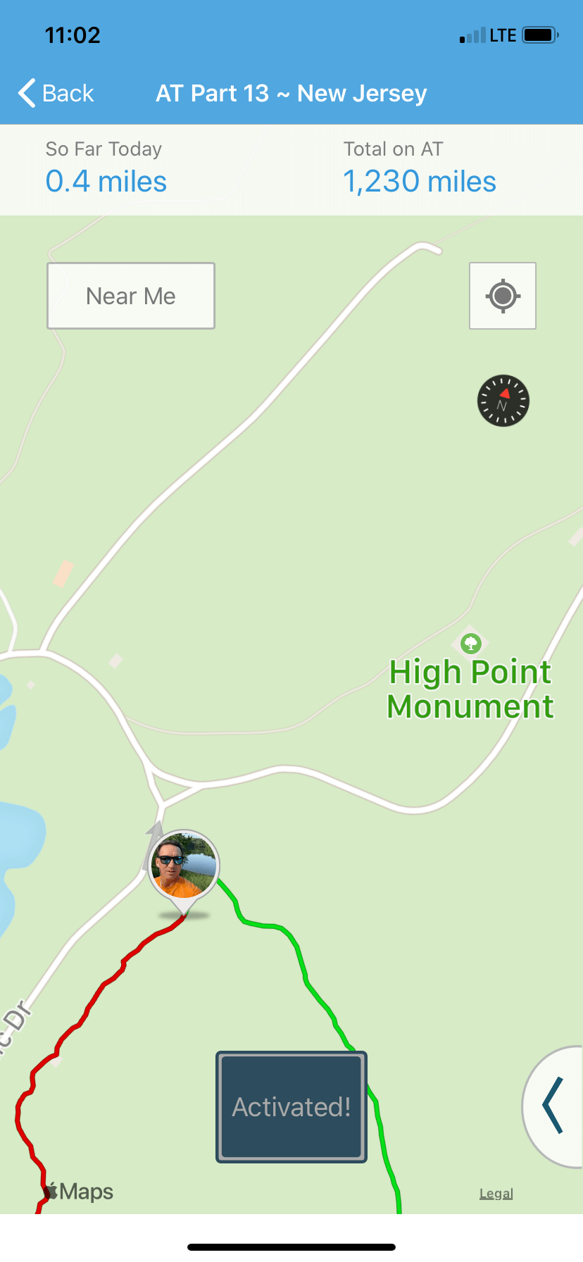
In effect, I was walking on the actual location that coincided with my position on my virtual walk! How many times in life does “virtual” and “reality” meet up with each other?
One thing I noticed was that while the app had information about the High Point Shelter, there was no picture of the Monument. Maybe it’s because the monument is not on the AT (it’s ½-mile up a side trail). I planned to take pictures of the monument and sent them to John with the hope that he includes my monument picture and information in the app. Plus when you hike the AT in High Point the trial is pretty closed in with very few views of this beautiful part of New Jersey.
I hope the app will inform users that New Jersey isn’t just the Sopranos TV series and the New Jersey Turnpike!
If you are looking to spice up your walking routine, I recommend Walk the Distance. It’s easy to use and will give you a push to add that extra mile or two as you make your way over the Appalachian Mountain Range and up the east coast of the United States.
Most of my Walking for Health and Fitness posts deal with walking on the road, local parks, or tracks. Walking in High Point is about walking in the woods or “hiking”. It’s been a while since I spent a day in the woods hiking so the trip to High Point had me excited about taking pictures of the monument and finding things to write about.
Walking the Appalachian Trail in High Point State Park
I arrived at High Point (view the park map) via Route 23 which runs straight through the park. I paid the weekday fee of $5 and stopped at the bathhouse and looked out over the swimmers on Lake Marcia. Then I drove up to the monument and parked in the lot just north of it. I walked up the road leading to the monument and checked out the spectacular view of New Jersey to the south, New York to the northeast, and Pennsylvania to the northwest as the three states meet just 3 miles away.
I found the Monument trail at the north corner of the monument and walked downhill for a half-mile until I joined the Appalachian Trail. I then headed south for another half mile to the lookout deck and climbed the steps to the top. If an AT through hiker doesn’t want to take the monument trail to see the view, then this is the only chance to look out onto the vast expanse of land in this part of NJ. Just past this lookout, there are very few chances to see the monument in the distance and it is a pretty cool sight to see as it rises about the forest.

Hiking on the AT in this section is very difficult. The number of large jagged rocks you must navigate makes this a real workout. When I walk on the road, it’s effortless as there is little need to look down at the road surface as it’s mostly smooth. That’s not an option on the AT here in High Point, it’s tough-going!
Along this section, I meet up with a “semi” through hiker. The “Librarian” had joined her friends in Southern Pennsylvania and was planning on hiking to the NY/Conn border then end her 2-month journey. She is a librarian and was furloughed from her job in Brooklyn because of the Covid-19 pandemic. I wished her well and continued hiking south.
I hiked 1.5 miles and came to a clearing where the trail crosses Route 23. On the other side, I came to a junction of the AT and the Iris Trail. I took the Iris because the path is so much easier to walk. It had very few rocks and was easy on the feet and legs. I believe when they laid out the route to the AT a requirement was that it had to go over every rock and difficult path in the area! 1.5 miles later I took a short side trail to the banks of Lake Rutherford took a few pictures then headed back north towards the monument.
High Point State Park offers visitors a variety of trail options throughout the year, designated multiple-use trails are available for hiking, mountain biking, horseback riding, cross country skiing, snowshoeing, dogsledding and snowmobiling. With over 50 miles of trails, trails vary in length from one half-mile to 18 miles and take visitors through unique and diverse landscapes including an Atlantic white cedar swamp, mountain ridge tops with 360-degree views, dense forests, fields, and wetlands.
Other Walking Options in High Point State Park

You always have the option of walking along the road at High Point. Since there aren’t many roads that run through the park, traffic is light as most people just park their cars and access the trail system or enjoy a day at the lake.
The scenic roadway is a one-way single lane road that begins just inside the park and takes you up the mountain and ends just below the monument. This is a great walking option. It’s hilly but shaded with a few short side roads that end with picnic tables nestled in the woods. A walk from the entrance of High Point to the monument and back is approximately 3 miles.
Another walking option is along Sawmill road which is located north of the park entrance. Sawmill road leads to the many campsites located in High Point and the roadway is tree-lined and extends for many miles.
Dryden Kuser Natural Area
Dedicated in 1965, the 850-acre Dryden Kuser Natural Area was the first natural area in the State of New Jersey.
The Atlantic white cedar swamp in Dryden Kuser Natural Area is located at 1500 feet above sea level and is the highest elevation swamp of its kind in the world. A self-guided trail booklet for those who wish to hike the swamp trail is available here.
Endangered species include the three-tooth cinquefoil and Cooper's hawk.
Swimming at High Point State Park
20-acre Lake Marcia is a spring-fed lake that is cool and refreshing for swimmers. Swimming is permitted in the designated area while lifeguards are on duty. A bathhouse and food concession is located near the beach.
Winter Options at High Point
Winter months find cross-country skiers on the 15 km of groomed trails in the park. Cross-country skis and other winter sports equipment are available for rent. A blazing fire, hot soup, and other hearty food greet visitors at the center on Lake Marcia
About the Appalachian Trail In New Jersey
The New Jersey section of the Appalachian Trail is approximately 72 miles long. It enters the state at the Delaware River National Recreation Area and exits into New York just west of Greenwood in the Hewitt State Forrest Area.

The trail follows the Kittatinny Ridge from the Water Gap, then into Stokes State Forrest, and continues into High Point State Park. Just shy of Veterans' Monument the trail turns and heads east and runs parallel to the NY/NY border until finally turning north into New York at Hewitt State Forrest just north of Surprise Lake.
Once you climb up the trail at the Water Gap, the nearly 40-mile journey to High Point is at a steady elevation on the Kittatinny Mountain Ridge.
There are many places along the New Jersey section that you can park your car, day hike, and see some outstanding sites. The areas surrounding the trail are rural and mostly undeveloped.
Caution - Black Bear Warning: New Jersey holds the claim of having both the highest population density of humans AND black bears in the country.
Why is the Appalachian Trail is so Important?
The importance of the trail is that half of the U.S. population, more than 150 million people, live within a day's drive of the Appalachian Trail and 2-3 million people walk a portion of the trail.
The A.T. traverses some of the most scenic mountainous, woodland, and pastoral areas in the eastern United States. Every year, approximately 2500 hikers attempt a thru-hike but only about 500 complete the entire route.
It’s easy to reach a section of the trail near you so research your area and spend the day on the AT, you won’t regret it
The AT stretches across 14 states. Most thru-hikers begin in the south, usually in March, and hike north to follow the warmer weather. Running from Springer Mountain in Georgia to Mount Katahdin in Maine, the Appalachian Trail follows the Appalachian mountain range through 14 states: Georgia, North Carolina, Tennessee, Virginia, West Virginia, Maryland, Pennsylvania, New Jersey, New York, Connecticut, Massachusetts, Vermont, New Hampshire, and Maine.
The Appalachian Trail’s tallest peak, Clingmans Dome in Great Smoky Mountains National Park, tops out at 6,643 feet above sea level, whereas nothing in the Mid-Atlantic or southern New England states even reaches 4,000 feet. In his book, Skywalker--Close Encounters on the Appalachian Trail, author Bill Walker noted that the creators of the AT must have insisted on hiking over every peak between Georgia and Maine instead of taking an easier, less hilly, route around. What became frustrating to him was that because the elevations are so low and treelined, many peaks did not even offer a view worth climbing too.
Read more about the history of the Appalachian Trail
While I usually write about walking on the roads and local parks, getting out on a trail and hiking is a great change of pace. Variety is the spice of life! If you plan on hitting the trails, make sure to take along plenty of water and carry a snack if you plan on spending a few hours out in nature. Also,bring bug spray and sunscreen.
Use common sense to stay safe: carry a cellphone, tell someone where you will be hiking, when you will be returning, and make sure you call them when you are back in your car.
Lastly, have fun! Take plenty of pictures and enjoy your time in nature with all the peace and quiet away from the noise of cars, trucks, and landscape crews.
Walk on,
Frank
Author: Walking for Health and Fitness, Fitness Walking and Bodyweight Exercises, and Walking Inspiration.


